Potential Uses of Airborne Scanning Lidar for
Inventory of Forest Stands
by Joe Means
Department of Forest Science, Oregon State University
Advances in technology have contributed to changes in forest inventory practices in the
last 10 years. For example, laser tree height measuring devices, like the Criterion™
or Impulse™ have increased the speed and accuracy of measuring tree heights. This is
just a better way of collecting the same inventory measurement, individual tree height. In
the not too distant future we may see remote sensing tools, such as digital imagery with
small pixels, synthetic aperture radar and airborne scanning Lidar make larger changes in
how inventories are conducted. While ground surveys will still be essential, new remote
sensing tools will become an important part of the forest inventory process for landowners
who choose to use them.
In this short article I will briefly describe airborne scanning Lidar ( LIght Distance
And Ranging), the kinds of tree and stand measurements that can be derived from Lidar
data, and finally its potential place in forest inventory. A Lidar instrument is mounted
in a plane or helicopter and short pulses of laser light ping the earth’s surface a
little like radar in a zigzag pattern as the plane moves forward, covering a swath 100 to
400 m wide. Unlike radar, however, the laser beam is very narrow and a footprint from a
pulse is perhaps 0.1 to 1 m in diameter. The light is of a much longer wavelength than
most animals can see and is eye-safe by FAA regulations. An onboard kinematic GPS gives
position of the plane to within 10 cm and the pitch, roll and yaw and angle of the beam
are known quite accurately. This information and the round trip time for the light pulse
allows calculating the position of each reflecting surface to within 15 to 30 cm in
vertical and horizontal directions. A Lidar operating at 15,000 pulses per second in a
plane can cover forestland quickly. Newer Lidars record the first reflection (at the
canopy top) and last reflection (in the canopy, understory or on the ground, depending on
canopy density).
Some last reflections will be from the ground, and these are used to make a digital
terrain model, or topographic map of the ground under the vegetation. Canopy height can be
calculated from the ground elevations and stand canopy top elevations. Some pulses will
encounter gaps between tree crowns and can be used to calculate canopy closure percent.
For a given species in even-aged stands equations can be built between field data and
Lidar data so that Lidar-derived canopy height and canopy closure can predict features
like field-measured height and canopy closure. Theoretically, the vertical distribution of
Lidar reflections in the canopy will allow an estimate of canopy depth for the stand. This
will be enough to allow estimating crown ratio, volume and stem density for the stand. In
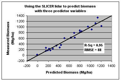
one ecological study in stands including old-growth, total stand biomass which is closely
related to stand volume, was estimated with an RMSE of 88 Mg/ha (see figure below) or
about 2,800 cuft/acre. Relationships should be better for managed stands 5-60 years old.
Lidar (and or other advanced remote sensing techniques) may well become important in
forest inventory but will never completely replace field surveys for several reasons. The
quality of the predictive relationships and their applicability to an area depends on good
ground data. These techniques cannot forseeably provide information on defect. Lidar,
however, can provide a 100% sample of a stand, and may be able to replace a significant
portion of the ground plots. |